Coastlines are not fixed lines. They change with waves, wind, northerly events, hurricanes, sediment transport and human works that modify the way land and sea meet.
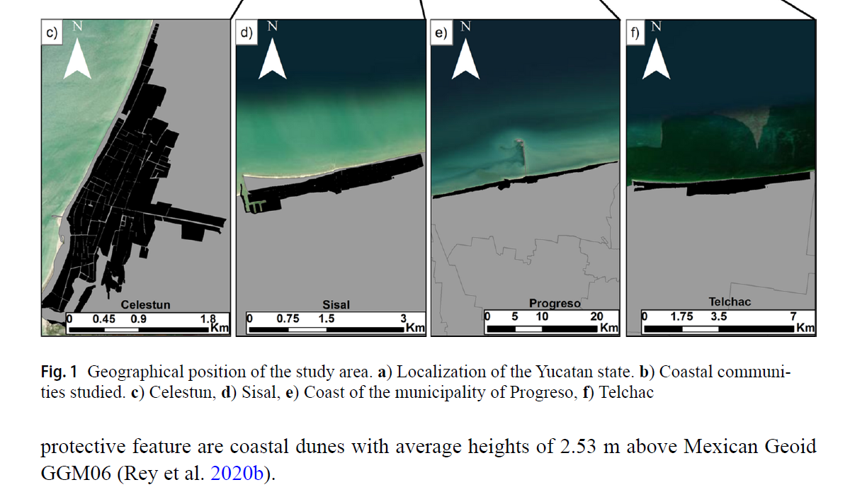
A 2025 study published in Natural Hazards analyzed four coastal communities in northern Yucatan: Celestun, Sisal, Progreso and Telchac. The research used high-resolution LiDAR data and two-dimensional hydrodynamic modeling to explore flooding scenarios associated with sea level rise toward the end of the twenty-first century.
What the study observes about Sisal
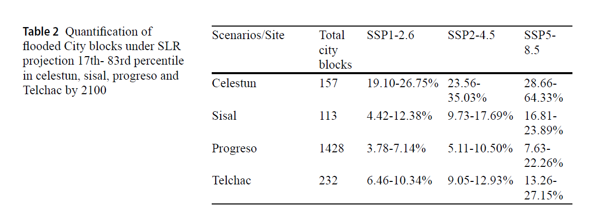
One of the most interesting results is that Sisal appears with relatively lower exposure under the scenarios analyzed. In the most severe scenario considered by the authors, the percentage of potentially flooded city blocks in Sisal is estimated between 16.81% and 23.89%, below Celestun and Telchac in relative terms.
The authors relate this lower exposure to several factors: the elevation of the barrier island, the location of city blocks in relation to the shoreline, limited hydraulic communication between the ocean and wetlands, and the beach-dune system that separates the settlement from the sea.
Dunes as a natural defense
The main reading should not be that Sisal has no risk. Rather, the study reminds us that dunes and landform matter for coastal protection. A dune is not only accumulated sand: it is part of a natural barrier that helps reduce the town's exposure to the sea.
For that reason, conserving the beach-dune system also means conserving a form of resilience. On a low coast, with wetlands and lagoons behind the beach, natural protection may not look like an engineered work, but it can be just as important.
Gilbert and an opening toward the wetland
Sisal's recent history also helps explain why today's landscape should not be read as something finished. The article mentions that, during Hurricane Gilbert, on September 14, 1988, a wetland area east of Sisal was opened toward the sea, forming a natural inlet and an evolving sand bar.
That episode shows the force that an extreme event can have in transforming the coast. A hurricane does not only remain in people's memory: it can also open passages, move sediments, modify wetlands and change the relationship between the sea and the back-barrier landscape.
Breakwaters, sand and land gained from the sea
Human interventions add another layer to that natural history. In coastal dynamics, breakwaters and other protection structures can modify wave action and longshore sediment transport. In some places they encourage sand accumulation; in others, they change the way the beach evolves.
In Sisal, the current configuration of the breakwaters coincides with a marked accumulation of sand on the western side, clearly observable in the recent evolution of the shoreline. Over the decades, this accumulation has generated new beach surfaces that are now part of the present landscape and can be related to the concept of land gained from the sea.
This point connects science with local memory. The landscape we see today is not only natural and not only built: it is a mixture of physical processes, extreme events and human decisions over time.
A transformation visible from space
In addition to scientific studies, the evolution of the coast can also be observed through historical satellite imagery. A Google Earth timelapse makes it possible to see how the shoreline has changed since 1984 and how sand gradually accumulated toward the western side of the breakwaters.
The images do not explain the causes of the process by themselves, but they help visualize a phenomenon studied through geomorphology and coastal dynamics. The observed accumulation is consistent with the idea of a changing coast, where natural processes, sediment transport and coastal works interact.
Observation: the timelapse shows the evolution of the landscape. Interpreting the causes requires the combined reading of scientific studies, cartography and field observations.
The present coastline on the map
The current configuration of Sisal can also be observed through cartographic references. When the current map is compared with the boundary available in INEGI cartography, the coastal strip formed toward the western side becomes especially visible, along with its relationship to the progressive growth of the beach observed in satellite imagery.

This comparison helps read the physical continuity of the coastline and relate current cartography to the recent evolution of the shoreline.
Reading the coast with more context
Together, satellite imagery, cartography and scientific studies help us understand that Sisal's coast continues to evolve. The sand accumulation observed toward the western side is one of the most visible changes of recent decades and helps interpret the present configuration of the shoreline. At the same time, it reminds us that coasts are dynamic systems where natural processes and human-built works interact.